If you want to develop expertise in the rapidly developing field of geospatial technology, you might consider enrolling in an online masters in GIS.


A geographical information system (GIS) uses geography and innovative software to manage, interpret, and map data. GIS is a relatively new field, but it already has many practical applications. For example, you can use GIS to identify floodplains, map pest-infested crop fields, and track urban development.
Editorial Listing ShortCode:
Earning a master degree in GIS can help you visualize the world in new ways and prepare you for many fascinating careers.
Online Masters in GIS Degree Programs


The acronym GIS can stand for geographic information science or geographical information system. GIS masters programs may use either term but still use similar approaches and have the same career outcomes.
Geographic information science refers to the methods and theories that shape geographical information systems. This discipline analyzes how humans perceive the world, and it uses sophisticated mapping technology to capture and visualize real-world phenomena.
Geographic information systems are the tools that geographic information scientists use to analyze data. Popular GIS software includes ArcGIS, BatchGeo, and Google Earth Pro. GIS experts use these systems to organize, manage, query, and map complex datasets.
Editorial Listing ShortCode:
A masters in geographic information systems (GIS) is an interdisciplinary degree that draws on geography, information science, and other fields.
Subjects typically taught in a GIS graduate program include:
- Cartographic design
- Data management
- Emergency management
- Environmental resource management
- Geospatial technology
- Image processing
- Programming languages like Jupyter and Python
- Remote sensing
- Spatial analytics
- System architecture
- Urban planning
Many GIS masters programs require students to complete a master’s thesis. These programs typically also include professional development opportunities like concentrations, internships, and networking events. These experiences can strengthen your resume and help you explore potential career paths.
Graduates with GIS masters degrees can pursue a growing number of career paths. Here are a few positions that GIS professionals may pursue:
- Cartographer
- GIS project manager
- GIS specialist
- Data scientist
- Surveyor
- Environmental scientist
- Geospatial analyst
- Remote sensing technician
- Software developer
- Urban planner
Because GIS is a developing field, new career paths will likely appear in the coming decade. The transferable skills you can gain in your masters program might help you prepare for roles that may not yet exist. A masters degree in GIS can be a strategic choice if you want to pursue a data-driven career that uses cutting-edge technologies to solve complicated problems.
Geographic Information Systems Careers and Salaries

A masters program in GIS can help prepare you for careers in a variety of industries. GIS has many real-world applications, and numerous employers are eager to use geospatial analysis to make data-driven decisions.
Areas where GIS professionals find work include emergency response, engineering, environmental science, government, healthcare, information security, marketing, and real estate. Some GIS specialists launch consulting businesses so they can work on a broad range of projects.
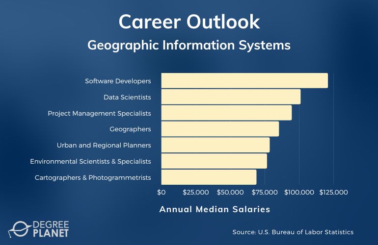
According to the Bureau of Labor Statistics, here are some positions associated with GIS, along with their median wages.
| Careers | Annual Median Salaries |
| Software Developers | $120,730 |
| Data Scientists | $100,910 |
| Project Management Specialists | $94,500 |
| Geographers | $85,220 |
| Urban and Regional Planners | $78,500 |
| Environmental Scientists and Specialists | $76,530 |
| Cartographers and Photogrammetrists | $68,900 |
| Surveyors | $61,600 |
| Geological and Hydrologic Technicians | $50,080 |
| Surveying and Mapping Technicians | $46,910 |
The Bureau of Labor Statistics predicts that some GIS-related careers will experience steady job growth over the next ten years. Examples of steadily growing jobs include environmental scientists and specialists, urban and regional planners, and surveying and mapping technicians.
Editorial Listing ShortCode:
Gaining additional qualifications and experience may help you secure higher-paying roles. For instance, you may boost your earning potential by completing an internship, earning a certificate, or learning more programming languages. Job qualifications can vary depending on the position, employer, and industry.
GIS Masters Online Curriculum & Courses


All GIS masters programs have different curricula, but you may take courses similar to these:
- Advanced Geographic Information Systems: This course teaches spatial analysis methods and tools, including GIS application development, network analysis, and 3D surface modeling.
- Advanced Python Programming for GIS: You’ll study advanced uses of the Python programming language, such as designing user interfaces and customizing GIS applications.
- Cloud and Server GIS: You’ll learn strategies to use cloud computing and GIS technologies to solve complex geospatial issues.
- Concepts for Spatial Thinking: You’ll gain a foundational understanding of spatial thinking and learn to implement these concepts in geographic information systems.
- Geographic Foundations of Geospatial Intelligence: You can learn fundamental principles of geospatial intelligence and its practical uses in emergency management, homeland security, and other areas.
- GIS for Health Analysis: This course examines how experts can use GIS to understand and visualize the spread of disease and other medical disorders.
- Remote Sensing for GIS: This class focuses on the theories and tools used to gather, evaluate, and implement digital image processing.
- Spatial Data Science for Emergency Management: You’ll study how GIS solutions can help communities and government agencies predict, prevent, and respond to emergencies.
- Spatial Databases: You’ll explore methods for creating and managing various types of geospatial databases, including object-oriented and relational databases.
- Web and Mobile GIS: You’ll gain hands-on experience with popular tools used to create GIS applications, including ArcGIS and Google Maps.
Many GIS master programs also require students to complete a capstone project or master’s thesis at the end of their studies.
Master’s Degree in GIS Admissions Requirements


Every masters program in GIS has a unique admissions process, but here are a few typical admissions requirements:
- Bachelor’s degree from a regionally accredited institution
- Resume detailing your relevant education, work experience, and skills
- GRE or GMAT scores (not all schools require them)
- Letters of recommendation from employers or professors
- Transcripts from previous educational institutions
It’s essential to research each school’s admissions requirements before you apply. This step helps ensure you have all the necessary materials and allows you to request letters of recommendation in advance.
GIS Master’s Programs Accreditation


Researching the accreditation statuses of schools that offer GIS master programs can help you find the right program. Colleges and universities can obtain regional accreditation by demonstrating that they meet specific educational standards established by an external organization.
Choosing an accredited school to earn your masters program in GIS can help you succeed academically and professionally. It’s necessary to be enrolled at an accredited institution to qualify for many financial aid opportunities, and you can transfer course credits more easily between accredited institutions.
Editorial Listing ShortCode:
You can verify a school’s accreditation status by visiting the US Department of Education’s website.
Financial Aid and Scholarships


You can apply for several kinds of financial aid to help pay for your masters degree in GIS. Many students qualify for financial aid from federal and state governments, such as grants, scholarships, or work-study programs.
The federal government also offers direct grad PLUS loans for graduate students. You can determine your eligibility for these programs by completing the Free Application for Federal Student Aid (FAFSA). Your GIS graduate program may also provide grants, scholarships, and teaching assistantships to eligible students. You can contact your school’s financial aid office to learn more about potential opportunities.
Other common sources of financial aid include community organizations and professional associations. These groups may offer grants and scholarships to students based on academic accomplishments, career goals, and financial needs.
It could also be helpful to ask your current employer if they have a tuition reimbursement program to help workers further their education.
What Can You Do with a GIS Online Masters Degree?


Much like with an online masters in geoscience, an online GIS master degree can help prepare you for a broad assortment of careers. Graduates of GIS master programs may use their geographical knowledge to pursue positions as cartographers, geographers, geospatial analysts, GIS specialists or analysts, and surveyors.
The versatility of GIS methods makes this field appealing to employers in many other industries. For example, some GIS professionals pursue career opportunities in agriculture, environmental science, healthcare, homeland security, urban planning, and transportation.
How Long Does It Take to Get a Masters in GIS Online?


You can typically complete a master degree in GIS in 2 to 3 years. Several factors can affect program length, though, including your enrollment status, the school’s course schedule, and the degree requirements.
For example, you may be able to complete a 36-credit hour program with no thesis requirement in as little as 1 year if you take summer courses. If you enroll full-time in a program with traditional fall and spring semesters, you can often complete your degree in 2 years. Enrolling part-time and completing a master’s thesis may add more time to your program.
Is a Master in GIS Worth It?


Yes, a master in GIS is worth it for many students. GIS has an enormous range of uses, and GIS specialists are constantly inventing new applications for this technology. This versatility means that GIS graduates may find employment in numerous industries.
Editorial Listing ShortCode:
You can use your expertise to make a meaningful impact in the areas that matter to you most. For example, you might use data to help communities recover from natural disasters or track the spread of contagious diseases. The Bureau of Labor Statistics projects 4% job growth for architecture and engineering occupations and 7% job growth for life, physical, and social science occupations over the next ten years.
Universities Offering Online Master of Geographic Information Systems Degree Programs
Methodology: The following school list is in alphabetical order. To be included, a college or university must be regionally accredited and offer degree programs online or in a hybrid format.


Elmhurst University offers a Master of Science in Geographic Information Systems. This program aims to help students develop spatial analysis, web mapping, and geospatial programming skills. On average, the degree requirements can be completed in 2 years. Graduates often pursue careers as cartographers, data scientists, GIS analysts, urban planners, and geospatial data engineers.
Elmhurst University is accredited by the Higher Learning Commission.

Johns Hopkins University offers a Master of Science in Geographic Information Systems. Start dates are offered in fall, spring, and summer terms. This program is housed 100% online. Full-time students can typically finish in 12 months, while part-time students can usually complete their studies in 24 months.
Johns Hopkins University is accredited by the Middle States Commission on Higher Education.

Pennsylvania State University offers a fully online program for a Master of Geographic Information Systems. Graduates often pursue careers in urban planning, resource management, or climate science. The program requires the completion of 36 credit hours. Specialization tracks are offered in Geospatial Intelligence and Geodesign.
Pennsylvania State University is accredited by the Middle States Commission on Higher Education.

The University of Arizona offers a Master of Science in Geographic Information Systems Technology. Potential courses include Vector Spatial Analysis, Open-Source GIS, and Remote Sensing Science. This program utilizes an entirely online learning format. The program’s 30 required credit hours can typically be completed in 18 months when attended full-time.
The University of Arizona is accredited by the Higher Learning Commission.


The University of Central Arkansas offers an online program for a Master of Geographic Information Systems. It is intended for students who have a baccalaureate degree and have completed at least one GIS course. The program requires the completion of at least 30 credits, and up to 6 qualifying credits may be transferred in.
The University of Central Arkansas is accredited by the Higher Learning Commission.

The University of Cincinnati offers a Master of Science in Geographic Information Systems. Courses cover topics like land-use planning, climate and environment, urban development, public safety, and design. This program is housed fully online and consists of 30 credit hours. It can potentially be completed in 18 months when attending full-time.
The University of Cincinnati is accredited by the Higher Learning Commission.
The University of North Dakota offers a Master of Professional Science in Geography. Students interested in careers that utilize spatial data and global cyberinfrastructure can select an emphasis in Geographic Information Science. On average, the program’s 30 required credit hours can be completed in 2 years when attended full-time. All coursework can be completed conveniently online.
UND is accredited by the Higher Learning Commission.


The University of Redlands offers a Master of Geographic Information Systems. This program combines convenient online coursework with hands-on internship experiences in the field. Potential courses include GIS for the Web, Geospatial Analysis, and Communication Graphic Information. The program’s coursework can potentially be completed in 17 months when attended full-time.
The University of Redlands is accredited by the Western Association of Schools and Colleges.

The University of Southern California offers a Master of Science in Geographic Information Science and Technology. The program offers three tracks: Spatial Data Management, Spatial Computing, and Spatial Analysis. It utilizes a convenient, 100% online learning model. The curriculum consists of 28 units.
USC is accredited by the Western Association of Schools and Colleges.

West Virginia University offers a Master of Science in Geographic Information Systems and Spatial Analysis. Many graduates pursue careers in higher education, information technology, or government agencies. The curriculum consists of 10 courses for a total of 31 credits. Start dates are offered in spring, summer, and winter terms.
West Virginia University is accredited by the Higher Learning Commission.
Getting Your Master of GIS Degree Online


A masters program in GIS allows you to gain advanced knowledge of geographic information science and geographic information systems.
You can learn how to transform data into compelling visualizations that help organizations make strategic decisions. You can also develop many versatile technical skills, like coding, database management, and network analysis.
A graduate degree in GIS can help prepare you for careers in a broad range of industries, such as environmental science, healthcare, and urban planning. The Bureau of Labor Statistics forecasts that many GIS-related jobs will experience average or faster-than-average growth.
You can begin your GIS journey today by researching accredited online programs.